Blackfoot Covid-style
Thanksgiving Monday October 12, 2020
Out-of-town event at the Waskehegan Staging Area of Cooking Lake-Blackfoot Provincial Recreation Area.
52365 RR210, Sherwood Park (putting that into Google maps may not work). Driving directions at the bottom of the page.
This FREE event is being put on using Covid protocols from Orienteering Canada to maintain/encourage physical distancing to ensuring the safety of all participants and organizers. Protocols include:
– 2020 EOOC members only
– registration on-line only, closes on SATURDAY (NO on-the-day registration)
– maps pre-printed for all participants.
– start times will be assigned over a longer window.
– masks to be worn before and after the event, and carried on the course.
– members bring their own water, snacks, whistle (compulsory, but any kind will do), compass (any kind will do). Sorry, no rentals available.
– members will be required to read and sign the new Orienteering Canada waiver.
There will be orienteering flags with numbers at all controls; we will NOT be using SI electronic timing. Participants can self-time or use the optional MapRunF app (map to be downloaded at home; code supplied on site).
Terrain: large undulating grazing fields surrounded by fences. with some areas of woods and wet areas.
The courses will be in Fields 7B and 7C. The fields are much drier than they were in the spring. The cows have been in 7C to “mow” the grass (and moved on). The grass in 7B is runnable, but still LONG and fallen over. There are NO MOSQUITOES.
Fences: the ones separating the fields from the dark green areas are usually barbed wire; the rest are tight wires, which you can go under or between.
Map information:
Boulders should be at least 1metre tall, but the ones on the Blackfoot map are really only rocks, but conspicuous rocks. On the control description, boulders are shown as a solid triangle.
Green Os are distinct single trees.
Green Xs are rootstocks – trees that have fallen over and are showing their roots. The control description symbol for a rootstock is a circle with a full size X inside.
Black Xs are brush piles.
Trails: Not all trails are mapped; only the more distinct ones are shown.
Map scale (with contour interval 2.5m) : 1:8,000 (all courses)
SAFETY BEARING for all courses is WEST to a fence or road.
Courses:
Distances are as-the-crow-flies and do NOT include the 250m walk to and from the start/finish :
–Course 1: easy, suitable for beginners and families with small children
– Course 2/3: novice/intermediate. Controls on linear features (such as fences, paths, vegetation edge) with simple route choices, all in a pasture surrounded by a fence.
– Course 4: intermediate/advanced, not following handrails.
– Course 5: advanced course, about 5km.
– Course 6: advanced course for those who have done the Blackfoot independent courses, about 6km.
– Course 7: advanced course, about 7km.
SAFETY BEARING for all courses is WEST to a fence or road.
Facilities: Waskehegan Staging Area has a shelter and better-than-average outhouses, picnic tables. Participants will be discouraged from congregating in the shelter.
What to bring: compass, whistle, face mask, water, snacks.
Hat, sunscreen, (sunglasses?)
Extra socks and shoes for afterwards.
RSVP here: https://zone4.ca/register.asp?id=24638
Organizer:
Course Planner – Geraint Edmunds, Orienteering Canada certified Level 300 Official
More information:
Check back to this web page for updates or email Marilyn <eooc<AT>shaw<DOT>ca>
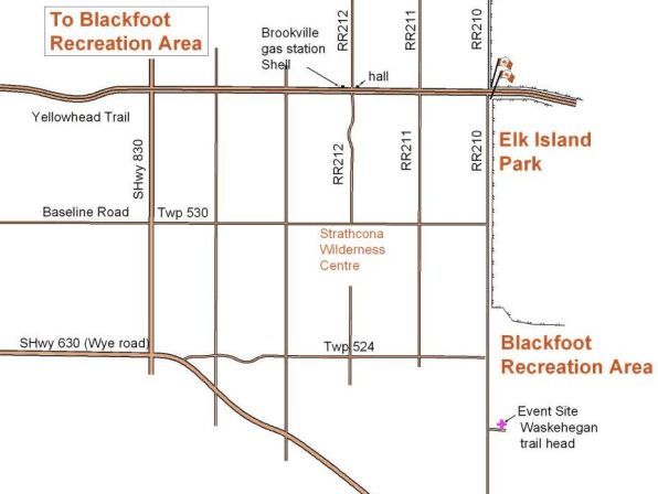
DIRECTIONS: 20km east of Sherwood Park
Easiest route is east along the Yellowhead Hwy 16 to the Elk Island National Park flag pole, then south down RR 210 for about 7km. Turn left/east into the Cooking Lake / Blackfoot Provincial Recreation Area, Waskehegan Staging Area parking lot. Check in /Map pick up will probably be in the shelter on the east side of the parking lot.
Exit 58 from the Anthony Henday, then east along Baseline Road (with shops and restaurants) which becomes Twp 530, to the T junction with RR210. Turn right and go south for about 4km. Turn into the Cooking Lake / Blackfoot Provincial Recreation Area, Waskehegan Staging Area parking lot.
Map pick up will probably be in the shelter on the east side of the parking lot.
Exit 61 from the Anthony Henday, then east along Wye Road. Just after the road bends to the southeast, turn left onto Twp 524, crossing the railroad tracks. Continue east to the T junction with RR210. Turn right and drive south for just over 1km. Turn into the Cooking Lake / Blackfoot Provincial Recreation Area, Waskehegan Staging Area parking lot. Map pick up will probably be in the shelter on the east side of the parking lot.
Brookville Hall has a distinctive steep-pitched roof.
Brookville gas station is no longer a Shell station (has pumps only)
