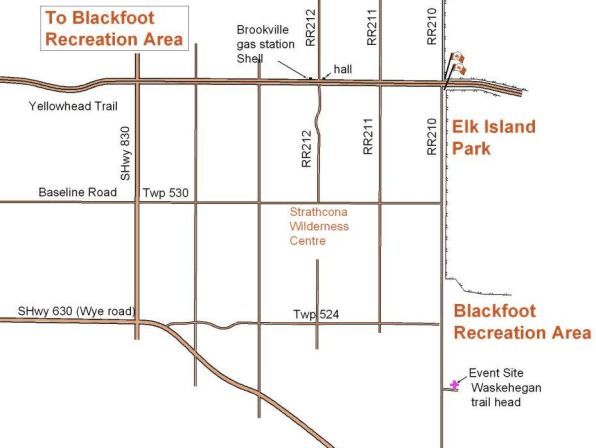
Blackfoot Directions and Location Map
to Waskehegan Staging Area
DIRECTIONS: 20km east of Sherwood Park (about 35 minutes drive)
Easiest route is east along the Yellowhead Hwy to the Elk Island National Park flag pole and a sign to Cooking Lake/ Blackfoot Provincial Recreation Area, then south down RR 210 for about 7km. Turn left into the Cooking Lake / Blackfoot Provincial Recreation Area, Waskahegan Staging Area parking lot. Registration/check-in is usually close to or in the shelter.
Or east along Baseline Road (becomes Twp 530) to the T junction with RR210. Turn right and go south for about 4km. Turn into the Cooking Lake / Blackfoot Provincial Recreation Area, Waskahegan Staging Area parking lot. Registration/check-in is usually close to or in the shelter.
Or east along Wye Road. Just after the road bends to the southeast, turn left onto Twp 524, crossing the railroad tracks. Continue east to the T junction with RR210. Turn right and drive south for just over 1km. Turn into the Cooking Lake / Blackfoot Provincial Recreation Area, Waskehegan Staging Area parking lot. Registration/check-in is usually close to or in the shelter.
The Brookville gas station is no longer Shell.
Brookville Hall has a distinctive steep-pitched roof.
If you need to Google the location, type in Waskehegan Staging Area.
