Forest Event at the Redwater Natural Area  

UPDATE: course lengths and map scale added. 700m walk to the start [April 24];

Reminder: bring a watch and your own water supply if you are planning to do the Goat or Half Goat.

Date: Saturday May 15, 2010 

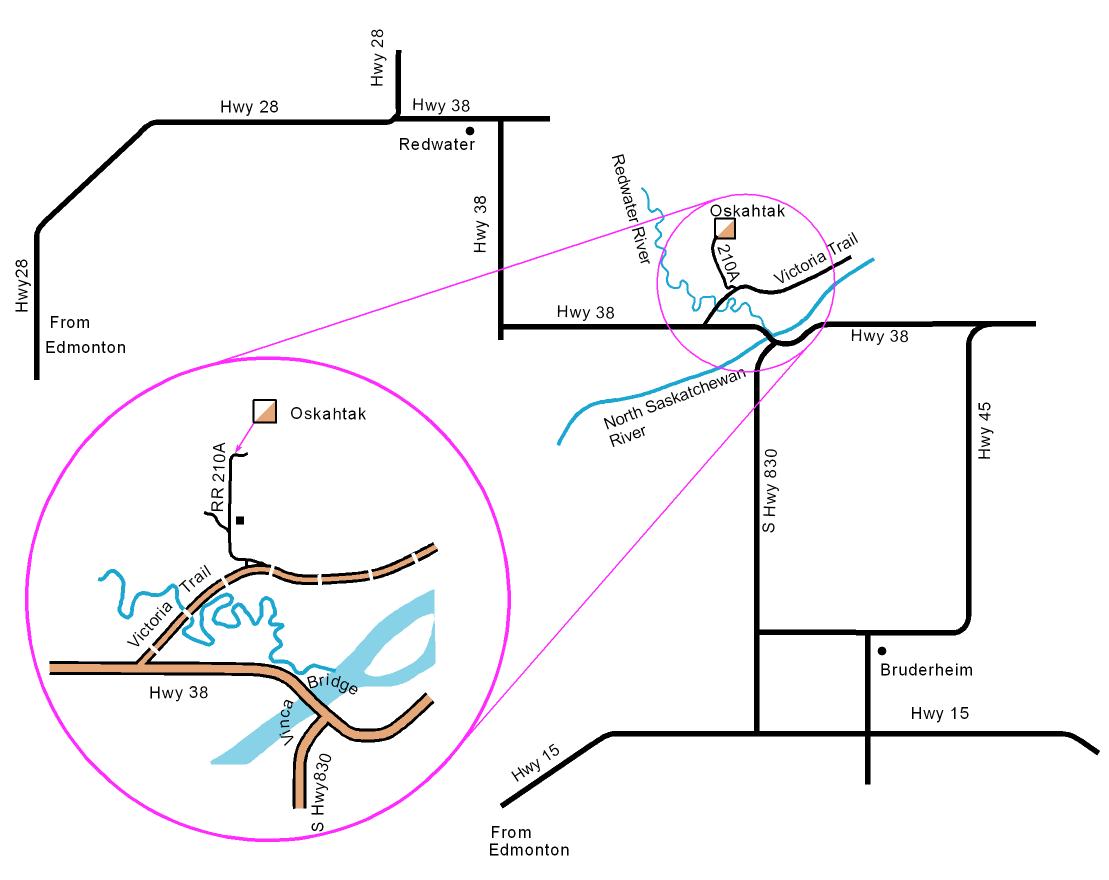
Redwater Natural Area, approx 30km northeast of Ft Saskatchewan. (NOT the same start area as last year)  See directions below.

This is 2 events in one, with different registration and start times and different fees.
Choose the Goat-and-a-half event (17.7 km or 9.0km) or the regular courses event
Timetable:
REGULAR COURSES   Goat and half Goat courses 
  10:00 registration opens for Goat & half Goat
  10:45 registration closes for Goat & half Goat.  Assemble for last minute instructions.
700m walk to the start.
  11:00 mass start for Goat & Half Goat
registration opens for regular courses 11:05  
participants may start 11:15  
registration closes for regular courses 1:00pm  
last time to start for regular courses 1:30pm  
  3:00pm course closing for half Goat and for map exchange for full Goat
courses close for regular courses; everyone on these courses must check back in by this time. 4:00pm mug deadline
  6:00pm courses close; everyone must check back in by this time

Goat and half Goat event

A Goat is a mass-start extra long orienteering course. It begins with 4 controls which can be taken in any order, followed by a regular point-to-point course, except that participants may skip one (or two) controls. The Goat is usually 17-19km long with a map exchange mid way. Those who finish the full goat within 5 hours win a limited-edition mug.    Goat Rules

A half goat, as far as the map exchange (9.0km), is also offered at regular prices per person (no chance to win the mug). 

Map: Oskahtak and Dalmuir  1:15,000;  2.5m contours
Register: on site from 10:00 am
Assemble for last minute instructions at 10:45 am
Mass Start: 11am for Goat & Half Goat
Course Closes
3:00 pm for half goat and map exchange.  Full goat participants who do not reach the map exchange by this time will not be allowed to continue.  All Goat and half Goat participants should try to check in by 3pm.  Controls on this section will be picked up soon after this deadline.
4:00 pm mug deadline
6.00 pm everyone must report back in by this time, finished or not.
Fees: per person: (participants may compete as a team, but must pay individually for the Goat and half Goat.)
$30 for the full Goat (includes  SPORTident electronic card rental** if needed)
$7 + $2** SI electronic card rental** for members for the half goat
$9 + $2** SI electronic card rental** for non-members for the half goat
$1 for compass rental**;  $1 for whistle purchase
** deposit such as drivers license required for rentals

Goat participants take: All participants must carry a whistle and a watch. Although there will be water stops on the course, it is recommended that you carry your own water supply (and snacks). Cell phones work on this map . Long pants and long sleeves are strongly recommended. As the weather can change dramatically over 5-7 hours a windbreaker would be a good idea.

Return to top of page

Regular courses

Map: Oskahtak 1:10,000  2.5m contours
Register: on site from 11:05pm  - 1:00 pm.  No pre-registration required.
Starts: 11:15 pm - 1:30 pm
Courses Close: 4:00 pm - all participants on these courses must check back in by this time
Courses:
#

difficulty

length

1/2 Beginner/Novice: this course starts with the first few controls on trails, then progresses to controls just off the trail, ending with a few controls 50-100m from trails. 2.4km*
3 Intermediate: controls across country 3.9km*
4 Technically advanced 4.7km*

*  distances are as the crow flies and do not include the 700m walk to the start

Entry Fees:
Members (EOOC/AOA), per map, which you may share
plus SPORTident electronic timing rental  (drivers license or equivalent required as deposit)
 $7
+$2
Non-members, per map, which you may share
plus SPORTident electronic timing rental  (drivers license or equivalent required as deposit)
 $9
+$2
Additional maps for couples/groups going out together, each $3
Compass rental (drivers license or equivalent required as deposit) $1
Whistle (compulsory) - bring your own or buy one from the registrar for $1
Bring:  a watch, whistle and compass (if you have them).  Wear very old clothes and come prepared for changes in the weather. 

Directions:              

Location map

Referring to a provincial road map, take Hwys 21 and/or 15 past Fort Saskatchewan to Secondary Highway 830.  Turn north (left) onto SH 830.  At the end of SH 830, turn west (left) onto Hwy 38 and cross the Vinca Bridge over the N Saskatchewan River.  Approximately 1.5km after crossing the bridge turn right (northeast) onto Victoria Trail.  1.8km along Victoria Trail (which includes crossing the Redwater River on a one track bridge), turn left (north) onto RR210A*.  Make another left immediately at the T junction.  From here you just follow RR210A for about 1km - it will go a few hundred metres west then bend to the north; drive slowly past the house because of a car-chasing dog!   Parking will be on one side of the the Range Road.  Please park the same side as everyone else.
*   reddish orange and white orienteering signs will be posted from the turn off Victoria Trail.

Event Organiser Greg Yarkie, COF certified official, Level 2
More Info
Greg, organiser,  <goat10@orienteeringalberta.ca>  
Marilyn,    Events Coordinator   (780) 455 1916


Hit Counter